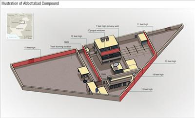
Crucial information used in the planning and execution of the raid this week that killed Osamabin Laden came from a gleaming office building just across the street from the Home Depot in Arnold.
From there, everyone from top national intelligence officials to the Navy SEALs accessed maps, data and other information maintained by the National Geospatial-Intelligence Agency.
The agency uses information collected by satellites and other sources to develop highly detailed maps and rich visual imagery for the military, the CIA and other federal agencies.
"It's maps at one level, but it's sort of much more powerful than what people traditionally think ofas maps," said a senior agency analyst who asked not to be identified for security reasons.
The top-security Arnold facility is on Vogel Road, surrounded by high fences topped with razor wire. The building is off-limits to the public, and much of the agency's work is secret. |